gvSIG bugs #3743

Intersecting postgis layers wrong filled fields
| Status: | Outdated | % Done: | 0% | |
|---|---|---|---|---|
| Priority: | Normal | Spent time: | - | |
| Assignee: | - | |||
| Category: | Database | |||
| Target version: | - | |||
| Severity: | Minor | Add-on version: | ||
| gvSIG version: | 2.2.0 | Add-on build: | ||
| gvSIG build: | Add-on resolve version: | |||
| Operative System: | Add-on resolve build: | |||
| Keywords: | Proyecto: | |||
| Has patch: | Hito: | |||
| Add-on name: | Unknown |
Description
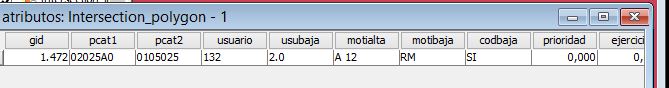
Doing the geoprocess, Intersect( wirh layers test1, test2). The graphical result is ok.
But when I open the attribute the values are mixed.
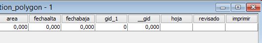
The result has the fields of both tables, but are wrong filled.
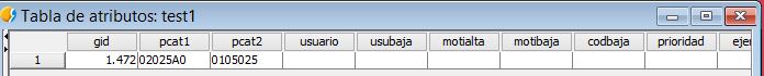
There's the test1 table, you can see that some fields are empty.
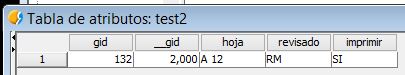
the table of test2 layer just have 5 fileds
The result of the intersection between test1 and test2 has the fields of both, but the values of test2 are placed in a wrong place.
 ...
... 
There's attached a backup of the database used.
tabla_test1.JPG (20.6 KB)
tabla_salida.JPG (23.7 KB)
tabla_test2.JPG (15.6 KB)
tabla_salida2.JPG (17.8 KB)
test.backup (8.24 KB)


History
#1
 Updated by Álvaro Anguix almost 11 years ago
- Category set to Database
#2
Updated by Álvaro Anguix about 6 years ago
- Status changed from New to Outdated