gvSIG bugs #4101

Save view to georeferenced raster fails with WMS layers if the view is maximized
| Status: | Closed | % Done: | 0% | |
|---|---|---|---|---|
| Priority: | Normal | Spent time: | - | |
| Assignee: |  Francisco Díaz Carsí Francisco Díaz Carsí | |||
| Category: | Raster | |||
| Target version: | 2.4.0-2821 (rev. org.gvsig.desktop-2.0.187) | |||
| Severity: | Minor | Add-on version: | ||
| gvSIG version: | 2.2.0 | Add-on build: | ||
| gvSIG build: | 2313 | Add-on resolve version: | ||
| Operative System: | Add-on resolve build: | |||
| Keywords: | Proyecto: | |||
| Has patch: | Hito: | |||
| Add-on name: | Unknown |
Description
1. Create a view and maximize it.
2. Load a WMS layer (for example: http://www.ign.es/wms-inspire/pnoa-ma)
3. Zoom in to get a scale around 1:5000.
4. Run the "Save to georeferenced raster" tool.
5. Select the area to be saved on the WMS image trying to cover most of the view area.
6. Change the Pixel size parameter to "0.5".
7. Set the name of the resulting file.
8. Apply.
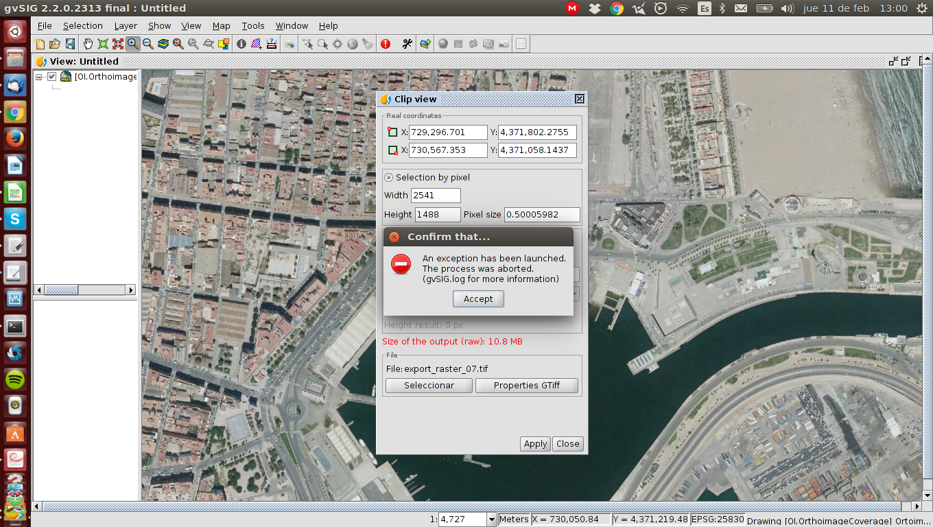
9. Before the process ends, an error message is thrown (see attached screenshot).
10. The file is generated but it looks incomplete.
Trying again but restoring the original view size, it works fine.
I'm also attaching a log file.

Associated revisions
refs #4101 Fixed:
- method to get adjusted envelope in ViewPort
- condition to draw in internalDraw method of AbstractVectorialLegend
- Fixed loadLayer method in RasterToolsUtil
refs #4101 Fixed:
- method to get adjusted envelope in ViewPort
- condition to draw in internalDraw method of AbstractVectorialLegend
- Fixed loadLayer method in RasterToolsUtil
History
#1
 Updated by Joaquín del Cerro Murciano about 10 years ago
- Target version set to 2.4.0-2850-final (rev. org.gvsig.desktop-2.0.220)
#2
 Updated by Álvaro Anguix almost 9 years ago
- Assignee set to Francisco Díaz Carsí
#3
Updated by Joaquín del Cerro Murciano almost 9 years ago
- Target version changed from 2.4.0-2850-final (rev. org.gvsig.desktop-2.0.220) to 2.4.0-2821 (rev. org.gvsig.desktop-2.0.187)
#4
 Updated by Francisco Díaz Carsí almost 9 years ago
Con las condiciones expuestas aquí por Manuel, se producían dos errores.
El primero en el propio proceso de creación del raster, por lo cual salía ese mensaje de error y no dejaba continuar el proceso.
Y una vez arreglado ese, se producía otro error al aceptar que cargue la capa en el toc.
Se han arreglado los dos.
Pero, cuando se selecciona que la capa WMS se cargue SIN caché de teselas en local, el resultado del proceso no es correcto.
Sin embargo, si se selecciona que la capa WMS se cargue CON caché de teselas en local, el resultado del proceso SÍ es correcto.
Se han subido los cambios que arreglan los dos primero problemas, pero dejo el tiquet abierto por si se desea abordar el resultado erróneo del proceso al cargar la capa sin caché de teselas.
#5
Updated by Joaquín del Cerro Murciano almost 9 years ago
- Status changed from New to Fixed
#6
Updated by Álvaro Anguix almost 9 years ago
- Status changed from Fixed to Closed