gvSIG bugs #4636

Strange projection discrepancy
| Status: | Closed | % Done: | 0% | |
|---|---|---|---|---|
| Priority: | High | Spent time: | - | |
| Assignee: | - | |||
| Category: | Raster | |||
| Target version: | - | |||
| Severity: | Major | Add-on version: | ||
| gvSIG version: | 2.4.0 | Add-on build: | ||
| gvSIG build: | Add-on resolve version: | |||
| Operative System: | Add-on resolve build: | |||
| Keywords: | Proyecto: | |||
| Has patch: | Hito: | |||
| Add-on name: | Unknown |
Description
I am not sure how to best summarize this, so I will try to give more information as possible.
Workflow:
0) my default prj for new map views is 32632
1) in gvsig I create a 3003 map view
2) I add a tiff that has a 3003 epsg projection inside
3) it recongnises the tiff as 32632 and wants to reproject it
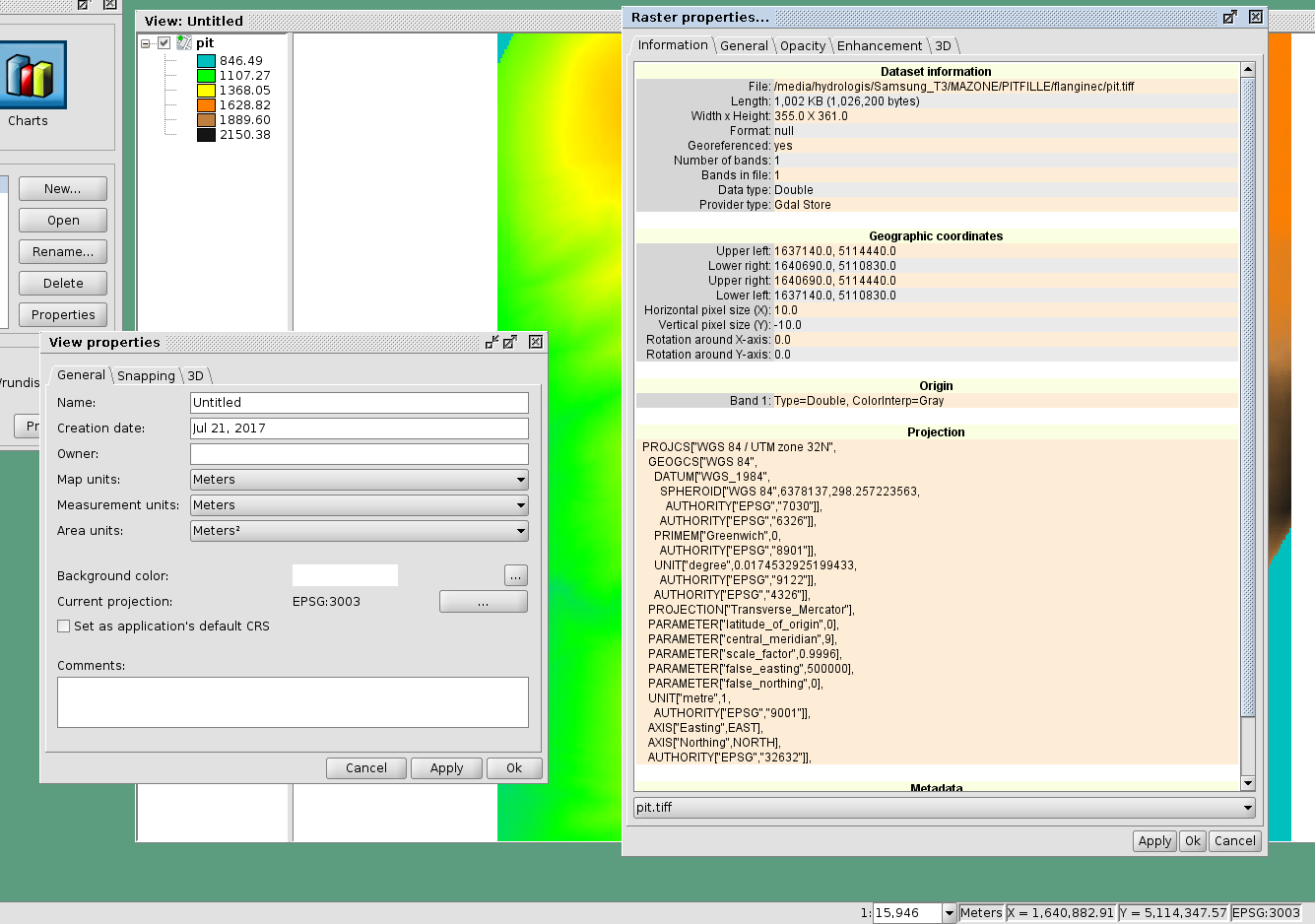
I noticed all this because I reopened a project that contained only that pit. The map is then properly set to 3003, but the layer is 32632 reprojected.
I attach an image with all those info and the tiff file used.
The result of gdalinfo is:
/media/hydrologis/Samsung_T3/MAZONE/PITFILLE/flanginec >>> gdalinfo pit.tiff
Driver: GTiff/GeoTIFF
Files: pit.tiff
Size is 355, 361
Coordinate System is:
PROJCS["Monte Mario / Italy zone 1 - Peninsular Part/Accuracy 3-4m",
    GEOGCS["Monte Mario",
        DATUM["Monte_Mario",
            SPHEROID["International 1924",6378388,297.000000000005,
                AUTHORITY["EPSG","7022"]],
            AUTHORITY["EPSG","6265"]],
        PRIMEM["Greenwich",0],
        UNIT["degree",0.0174532925199433],
        AUTHORITY["EPSG","4265"]],
    PROJECTION["Transverse_Mercator"],
    PARAMETER["latitude_of_origin",0],
    PARAMETER["central_meridian",9],
    PARAMETER["scale_factor",0.9996],
    PARAMETER["false_easting",1500000],
    PARAMETER["false_northing",0],
    UNIT["metre",1,
        AUTHORITY["EPSG","9001"]]]
Origin = (1637140.000000000000000,5114440.000000000000000)
Pixel Size = (10.000000000000000,-10.000000000000000)
Metadata:
  AREA_OR_POINT=Area
  TIFFTAG_RESOLUTIONUNIT=1 (unitless)
  TIFFTAG_XRESOLUTION=1
  TIFFTAG_YRESOLUTION=1
Image Structure Metadata:
  INTERLEAVE=BAND
Corner Coordinates:
Upper Left  ( 1637140.000, 5114440.000) ( 10d46'35.17"E, 46d10' 7.89"N)
Lower Left  ( 1637140.000, 5110830.000) ( 10d46'31.41"E, 46d 8'10.99"N)
Upper Right ( 1640690.000, 5114440.000) ( 10d49'20.63"E, 46d10' 5.29"N)
Lower Right ( 1640690.000, 5110830.000) ( 10d49'16.77"E, 46d 8' 8.38"N)
Center      ( 1638915.000, 5112635.000) ( 10d47'55.99"E, 46d 9' 8.15"N)
Band 1 Block=355x8 Type=Float64, ColorInterp=Gray
History
#1
 Updated by Antonio Falciano over 8 years ago
Hi Andrea,
I can reproduce the bug. First, it seems that the CRS of pit.tiff is missing an important information: the tag AUTHORITY. Without it, gvSIG is not able to recognize the CRS of raster layers and it assumes it's equal to the view one (EPSG:3003). Assumes, but not sets... Because if we add it and then check the raster properties, its CRS WKT is empty and further no rmf file is generated (1st issue). Then if we save and then reopen the project, checking again the raster properties we can see that it's set to the default one (EPSG:32632) and a rmf file is generated this time containing this wrong assumption... here's the 2nd issue!
#2
 Updated by Álvaro Anguix about 6 years ago
- Status changed from New to Closed
He probado en el 3016 y funciona correctamente.