gvSIG bugs #535

Confuse option in buffer geoprocess (field)
| Status: | Closed | % Done: | 0% | |
|---|---|---|---|---|
| Priority: | Normal | Spent time: | - | |
| Assignee: |  Ignacio Brodín Ignacio Brodín | |||
| Category: | Geoprocess | |||
| Target version: | 2.0.0-alpha6 | |||
| Severity: | Add-on version: | |||
| gvSIG version: | 2.0.0 | Add-on build: | ||
| gvSIG build: | 2045 | Add-on resolve version: | ||
| Operative System: | Add-on resolve build: | |||
| Keywords: | Proyecto: | |||
| Has patch: | No | Hito: | ||
| Add-on name: | Unknown |
Description
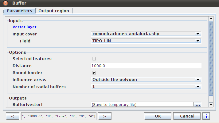
The dialog box ask for a "Field" but it's not clear what it does. In gvSIG 1.11 there was the possibility of take the buffer distance from the data stored in a field of the attribute table but it seems is not the same in this case.
The combo-box shows all the fields of the attribute table (whatever the type), including an extra field called "geometry" which doesn't appear when we open the attribute table.
Depending on what this control should do I will open new issues.
I attached a screenshot of the buffer dialog box in gvSIG 2.0
Buffer_dialog_box_gvSIG_20.png (32.8 KB)
History
#1
 Updated by Manuel Madrid almost 14 years ago
- Target version set to 2.0.0-rc1
#2
 Updated by Joaquín del Cerro Murciano almost 14 years ago
- Assignee set to Ignacio Brodín
- Target version changed from 2.0.0-rc1 to 2.0.0-alpha6
#3
 Updated by Ignacio Brodín almost 14 years ago
- Status changed from New to Fixed
The main problem is the field distribution in the GUI. SEXTANTE distributes these fields without programmer intervention. I have changed the labels for clarified a little bit the meaning but I think that we will have to update the user manual. Moreover this GUI does not permit labels with long text.
If you introduce a numeric distance then the field selected has not effect else will be valid the numeric distance.
#4
 Updated by María Maluenda almost 14 years ago
- Status changed from Fixed to Closed
Closed in the gvSIG build 2049