gvSIG bugs #683

Geoprocess gvSIG Intersection between polygon and line layers
| Status: | Closed | % Done: | 0% | |
|---|---|---|---|---|
| Priority: | Normal | Spent time: | - | |
| Assignee: |  Ignacio Brodín Ignacio Brodín | |||
| Category: | Geoprocess | |||
| Target version: | 2.0.0-alpha6 | |||
| Severity: | Add-on version: | |||
| gvSIG version: | 2.0.0 | Add-on build: | ||
| gvSIG build: | 2046 | Add-on resolve version: | ||
| Operative System: | Add-on resolve build: | |||
| Keywords: | Proyecto: | |||
| Has patch: | No | Hito: | ||
| Add-on name: | Unknown |
Description
Open gvSIG
Open new View
Add shape line layer-->geodata/vector/SHP2D/ Alicante_Comunicaciones_ICV_SHP2d/Alicante_Comunicaciones_ICV_SHP2d.shp
Add shape polygon layer-->geodata/vector/SHP2D/puentes.shp
Click in Intersection of tools geoprocessing toolbox gvSIG
Apply parameters: select input cover-->puentes.shp
Select overlay layer-->Alicante_Comunicaciones_ICV_SHP2d.shp
Save the Intersection in a temporary file
Intersection is created
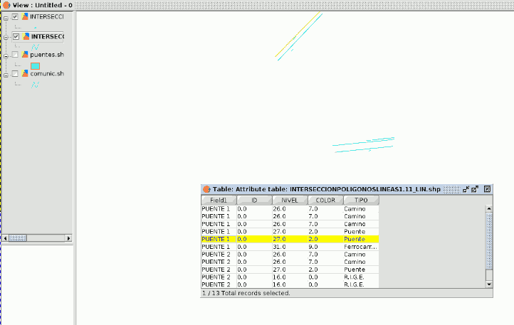
Intersection layer is created, but it hasn't made the Intersection layer correctly. You should see a linear layer, with the same fields as linear and polygonal layer base, with 13 records and a point layer with 1 record and with the same fields as linear and polygonal layer base.
Attached the resulting image obtained with the gvSIG version 1.11
1.-Abrir gvSIG
2.-Abrir una Vista nueva
3.-Añadir capa de lineal -> geodata/vector/SHP2D/Alicante_Comunicaciones_ICV_SHP2d/Alicante_Comunicaciones_ICV_SHP2d.shp
4.-Añadir una capa poligonal -> geodata/vector/SHP2D/puentes.shp
5.-Hacer click en la herramienta de geoprocesamiento de gvSIG "Intersección"
6.-Aplicar parámetros: seleccione la capa de entrada -> puentes.shp
7.-Seleccionar la capa de solape -> Alicante_Comunicaciones_ICV_SHP2d.shp
8.-Guardar la intersección en un archivo temporal
La Capa de intersección se crea, pero no ha hecho la capa de la intersección correctamente. Debería aparecer una capa lineal, con los mismos campos que las capas base lineal y poligonal, con 13 registros y una capa de puntos con un registro y con los mismos campos que las capas base lineal y poligonal.
Se adjunta la imagen resultante obtenida con la versión de gvSIG 1.11
INTERSECTION_POL_LINE_1.11.png (7.08 KB)

Associated revisions
references #683 Geoprocess gvSIG Intersection between polygon and line layers
references #683 Geoprocess gvSIG Intersection between polygon and line layers
History
#1
 Updated by Manuel Madrid almost 14 years ago
- Assignee set to Ignacio Brodín
- Target version set to 2.0.0-rc1
#2
 Updated by Ignacio Brodín almost 14 years ago
- Status changed from New to Fixed
#3
Updated by Ignacio Brodín almost 14 years ago
Outputs of this algorithm:
Pol-Pol: 3 layers (polygon, point, line)
Pol-Line: 2 layers (point, line)
Pol-Point: 1 layer (point)
Line-Point: 1 layer (point)
Line-Line: 2 layers (point, line)
Point-Point: 1 layer (point)
This process always loads three layers. If a layer does not contain data it is called Null_. This is a limitation of SEXTANTE.
#4
 Updated by Joaquín del Cerro Murciano almost 14 years ago
- Target version changed from 2.0.0-rc1 to 2.0.0-devel-2050
#5
Updated by Joaquín del Cerro Murciano almost 14 years ago
- Target version changed from 2.0.0-devel-2050 to 2.0.0-alpha6
#6
 Updated by María Maluenda almost 14 years ago
- Status changed from Fixed to Closed
Closed in the gvSIG build 2049